|
|
|
|
The Geography Of For Those In Peril On The Sea
Spoiler Alert: This page is intended for people who have already read For Those In Peril On The Sea, and may contain information that spoils your enjoyment of the story if you have not done so yet. 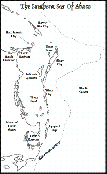 For Those In Peril On
The Sea is primarily set in the waters around the
northern Bahamas, and particularly the area of Little Bahama
bank known as the Sea of Abaco. All the locations referred to in the book are real world locations
(click here to
see an interacitve map),
although some artistic licence has been taken with the exact layouts of certain
buildings (such as the position of the Hope Town Lighthouse which has been moved
nearer the water) and areas (such as the Port of Miami - which, while set in the
real city of Miami, is largely fictional). As a result, the geography of this
regions plays as important a role in the story line as the characters. For Those In Peril On
The Sea is primarily set in the waters around the
northern Bahamas, and particularly the area of Little Bahama
bank known as the Sea of Abaco. All the locations referred to in the book are real world locations
(click here to
see an interacitve map),
although some artistic licence has been taken with the exact layouts of certain
buildings (such as the position of the Hope Town Lighthouse which has been moved
nearer the water) and areas (such as the Port of Miami - which, while set in the
real city of Miami, is largely fictional). As a result, the geography of this
regions plays as important a role in the story line as the characters.
The Bahamas are composed of a series of what are effectively large sandbanks. However this sand, rather than being made from crushed rocks, coral and shells, is made from calcium carbonate that precipitates out of sea water at high temperatures. Over millions of years this has created banks that rise almost vertically thousands of feet above the surrounding sea floor. This means that waters can change from a few feet deep to a few thousand feet deep over very short distances. There are two major banks in the Bahamas, Little Bahama Bank in the north, and the larger Great Bahama Bank in the south. The surfaces of these sand banks have become exposed and flooded many times since they were made as sea levels have risen and fallen. This has lead to the creation of many strange formations, including blue holes, sink holes, underwater cave systems, the natural arch at Hole-in-the-Wall, as well as the numerous islands, both large and small, that represent the tops of sand dunes created by the actions of the wind and sea when ever the sand banks were exposed to the air. The elements also fossilised these sand dunes to create the rocky limestone islands that we see today. This is because rain water partially dissolves the calcium carbonate particles that make up the sand and fuses them together. All of this means that most of the naturally occurring soil within the Bahamas is relatively poor, and it is only on the largest islands that have been exposed for the longest periods of time that agriculture can be sustained. This plays a critical role in the storyline of For Those In Peril On The Sea, when it becomes apparent that they will need to be able to grow fruit and vegetables if they are to avoid diseases associated with malnourishment.
The chain of islands that make up the Bahamas form an arc that goes from northwest to southeast, starting east of Florida and continuingdown to an area just off Hispaniola (the island that is inhabited by the nations of Haiti and the Dominical Republic). This, unfortunately, puts them directly on the path of hurricanes as they sweep first westwards across the Atlantic and then northwards, and the long-term average hurricane route tracks straight through much of the Bahamas. This means that hurricanes are a part of life there. The hurricane season lasts from June to November, with a peak between August and October, and in any one year, up to five or six hurricanes can make land fall. In some years, these will hit different parts of the Bahamas, while in others the same islands may get hit repeatedly. The pair of hurricanes that hit the Hope Town community in For Those In Peril On The Sea are based on a series of real storms that hit Abaco in the summer/autumn of 1999 when the islands were hit by three hurricanes and a tropical storm over a period of eight weeks. In particular, they are modelled on hurricanes Dennis (a minor storm than did little permanent damage) and Floyd (a major storm that wreaked havoc across the islands) from that year. Much of the descriptions of these hurricanes are based on the author's own experiences in the Abacos during these storms. |
|
All material on this website is copyright 2013 Colin M. Drysdale. This copyright applies worldwide as well as on the internet. While every effort has been made to ensure that the content of this website is accurate, it is provided on an 'as is' basis and there is no guarantee that it is correct. While you are welcome to consult this material while on this website, please do not copy it for use on other websites or for any other purpose without express written permission. Any links to this material from websites other than those of ForThoseInPeril.net must use 'Unmasked Forwarding' so that the original source of this information is clear at all times. In addition, this information should not be used for commercial purposes without prior consent. To discuss any copyright issues, including permission to use information from this website for other purposes, please email info@ForThoseInPeril.net
Send mail to
webmaster@ForThoseInPeril.net
with questions or comments about this web site.
|
 Because of its geology, the
Bahamas remains a low-lying nation, and most of it is under 300 feet above sea
level. Many of the smaller islands may only be 15 to 30 feet above sea level at
their highest points. However, these islands can still provide protection from
storms and the deep ocean. In particularly, along the eastern edge of Little Bahama Bank is a chain of barrier islands. These create a shallow, sheltered sea
that is a few miles wide between them and the island of Great Abaco further
west. This area, known as the Sea of Abaco, is the setting for much of the
second-half of the book.
Because of its geology, the
Bahamas remains a low-lying nation, and most of it is under 300 feet above sea
level. Many of the smaller islands may only be 15 to 30 feet above sea level at
their highest points. However, these islands can still provide protection from
storms and the deep ocean. In particularly, along the eastern edge of Little Bahama Bank is a chain of barrier islands. These create a shallow, sheltered sea
that is a few miles wide between them and the island of Great Abaco further
west. This area, known as the Sea of Abaco, is the setting for much of the
second-half of the book.